
Managing Planning Risk in Major Developments
David Kemp is the Director of DRK Planning Ltd. In this article, he shares how his company managed planning risk in a major development they recently undertook.

‘Good fortune is what happens when opportunity meets with planning.’ Thomas Edison
The complexity and risks of the planning process often mean that we have to manage cost exposure in proportion to planning risk as we go, especially on larger projects.
Our strategy is usually based around a three-step process normally involving:
1. Initial review and advice.
2. PD applications &/or Pre-application.
3. Full/Outline application
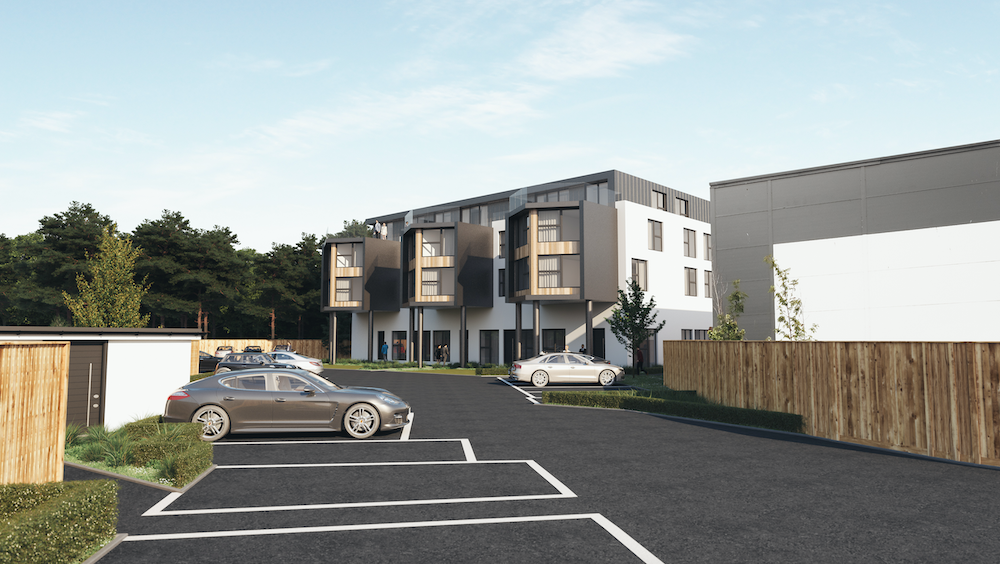
This was the case involving a development that we recently obtained planning permission on in Christchurch, near Bournemouth, on the South Coast for 46 new flats.

The Overall Strategy
The aim of the project was to obtain permission for 48 dwelling units in total within this 10,000-sq ft building. This would have required extensions to the building through an extra floor on the roof, bay extensions to the side and a small ground floor extension.
This needed a full application for planning permission at some stage. However, the change of use of the building to residential use meant that, tactically, it would be best to secure PD for change of use first, even though this would not yield the greatest number of flats.

Obtaining PD as a ‘Fallback’
As the building had a lawful B1 office use, that would have meant proving that it had been marketed for an extended period of time before applying for full planning to change the use (most Councils ask for evidence of at least 12 months of open marketing).
Most Councils will not be so strict on the need to ‘prove’ a period of marketing if Prior Approval for the change of use has already been obtained; this is called a ‘fallback’ position. The reasoning here is basically because if the Council know that Prior Approval has already been granted for the change of use, then they will not do much to stand in the way of something that is almost inevitable.
Usually when starting a project such as this, a Marketing or Valuation Report will have been produced by the bank’s valuers or surveyors, and this can be a useful starting point for the marketing evidence on local office demand and history of marketing of the building sought by the planners.
Therefore, we started off in May 2019 by obtaining Prior Approval for a change of use to 27 flats, which was granted 56 days later in July 2019.
The Effect of New PD Rights on Strategy
These PD rights for change of use will be carried over from the 1st August 2021 from Class O of the General Permitted Development Order 2015 to the new Class MA permitted development right. It should be noted that there are different conditions that apply to Class MA that do not apply to the current Class O (e.g. initial three-month period of vacancy before PD can be sought, floor limit of 1,500 sqm), so advice should be sought from an expert before assuming that your own building would also benefit in this way.
It should also be noted that the potential for a ‘fallback’ position did not just relate to the change of use. As a detached commercial building outside a conservation area, two other potential PD rights applied to the prospect of additional floors to the building, under Schedule 2 Part 20 of the General Permitted Development Order 2015 (amended in 2020). The first was to put up to two floors on an existing commercial building up to 30 metres (Class AA rights), and the other was to demolish the existing building and re-erect it with additional floors up to 18 metres (Class ZA rights).
After obtaining the PD for a change of use from the Council, we started to prepare our case for the additional floors and additional flats.
Dwelling Mix
It is often the case that the applicant’s perception of what size of dwellings or dwelling mix is justified in a proposal will not be shared with Council Housing or Policy Officers.
Each Council prepares its own Strategic Housing Market Assessment (SHMA). When preparing any planning proposal, you should look for this on the Council’s website; there might be an annual update on it known as the ‘Annual Monitoring Report’. It is usually tucked away in the ‘evidence-based documents’ section of the Council’s Local Plan pages.
The SHMA sets out what the Council perceives as its ‘priority dwelling mixes’. Unsurprisingly, this tends to be tilted toward larger units, often 2-bedroom and 3-bedroom units; this will not make for the optimum density scheme and will affect the end value. Therefore, it is always worth trying to push back against this by obtaining a Housing Market report from a very reputable firm of local residential agents (or you could go with a national firm with a local presence, e.g. Savills, Knight Frank, CBRE).
The Council was prepared to be flexible about this after seeing our Housing Market report. Initially, we had 90% of the scheme as 1-bedroom units. We offered a couple of extra 2-bedroom units, bringing the scheme down to 46 units from 48 units, with 80% of the scheme comprising 1-bedroom flats.
Flood Risk
The biggest sticking point in the scheme had to do with Flood Risk. It is here where we seemed to have trouble in making our case understood by officers.
Flood risk is assessed in applications for Prior Approval, but not as strictly as in applications for new build extensions in applications for planning permission.
When applying for planning permission, as opposed to Prior Approval, the Council asks for a ‘sequential test’ assessment. Paragraph 158 of the National Planning Policy Framework (NPPF) states that: ‘The aim of the sequential test is to steer new development to areas with the lowest risk of flooding. Development should not be allocated or permitted if there are reasonably available sites appropriate for the proposed development in areas at lower risk of flooding.’
On the Council’s Strategic Flood Map, a small corner of the building and some of the site falls within anticipated future Flood Zone 3a and Flood Zone 2.
The Council therefore required us to go through all of the sites allocated in the local plan for Christchurch for residential development and consider whether they would be a better alternative to our own site for residential development, especially where they were located in Flood Zone 1 instead. This is called ‘Sequential Testing’.
Problems with Sequential Testing
There are a number of problems with sequential testing, which make it very difficult to use to support a case for developing on land in Flood Zone 2 or 3, and these issues have been highlighted in planning appeal decisions that have gone against developers:
INCONSISTENCY: As the initial focus and sequential preference is on allocated sites, some of these will be in Flood Zone 2 or 3 anyway!
PRACTICALITY: In reality, although many sites might appear as ‘allocated’ in a Local Plan, this does not mean they are ‘likely to be developed’ in the near future – e.g. sites may be encumbered by poor access, ownership problems or lack of funding.
5-YEAR HOUSING TARGETS: Oddly enough, the Council can disregard the fact that it may be woefully short of its 5-year housing land targets, so even if the proposal site is desperately needed in order to meet these targets, it is irrelevant to passing the sequential test.
FRAGMENTATION: The Council can look to several sites to cumulatively provide the required number of houses that the proposal site would have provided on its own, so even if one or two of the allocated sites fail, an unspecified number of alternative cumulative sites might all together be sufficient to prevent the proposal from going ahead. What is not clear from the appeal decisions is to what degree it would be ‘reasonable’ for the Council to fragment the alternative distribution of sites – could you have this proposal for 46 dwellings fragmented over 46 separate Flood Zone 1 small sites for instance? It would seem unreasonable.
It is clear to see from the above problems that there is a danger of plenty of ‘grey areas’ in how this is applied, and we did find for several weeks we were going around in circles with officers.
Simplicity is Key
Looking at the list of problems thrown up by Sequential Testing, along with the communication challenges that we faced with officers working remotely, we needed to take a fresh approach urgently.
The solution was in the levels of the site.
LiDAR Mapping and Modelling Flood Risk
Rather than getting bogged down in the numerical exercise around sequential testing, we went back to the sole, single question that was at the heart of this issue: What is the likelihood of flooding to the proposed area of development?
In getting to the answer to this question, it is important to remember that flood maps produced by the local authority or by the Environment Agency only provide a 2-D analysis.
In order to get a full picture, one needs to look at changes in levels across a site and its topography and then one can also model likely patterns of flooding or water dispersion following a possible flooding event, hence the need to also look at LiDAR mapping of the site to build up a 3-D picture.
Put simply, a 2-D map might show the site as being within a Flood Zone 2 or 3, but if part of the site rises above the land around it (even only slightly), then in 3-D terms that part of the land might be relatively ‘dry’ and not so susceptible to flooding – i.e. practically speaking, equivalent to Flood Zone 1.
Opportunities for Development
Understanding that it may be possible to get around concerns over development of extensions or new buildings in Flood Zone 2 or 3 land, where it may be possible to make use of changes in topography and site levels, is key to unlocking opportunity on sites that others may have walked away from.
Therefore, in this case, where the proposed ground floor extensions to the building were in vulnerable areas of the site, we modelled the likely flow of flood waters using this 3-D approach and managed to persuade the Council that there would be no flood risk. Simply and succinctly put to the Council, this then became the main plank of our flood risk case and we decided not to push the sequential test case anymore due to its ambiguity and inconsistency.
Appreciating the key risks in a project of additional height, change of use and flooding starts at the very beginning with an initial appraisal by the planning consultant, of course helped with input from a flood risk specialist to test these issues early. The other two key issues of height and change of use can be mitigated through obtaining PD and establishing a ‘fallback’.
David Kemp BSc(Hons) MRICS Barrister*
(*non-practising)
Director, DRK Planning Ltd